When does navigating a watershed go from "public" to "private"?

FirstFreedom

Moderator
Suppose I'm on a public land with the early/upper parts of what eventually becomes major river running through it, and I start running a small boat upstream a few miles until the small river is more like a very large creek - at what point can the landowner consider me to be trespassing on his land?

On a large river, does the private landowner have the right to keep you out period, such that you're trespassing the instant you leave the public land, even if we're talking a river more than 2 stones throw's across, and easily navigable year round? Does it depend on the state and/or the particular area?
 
Not alot of knowledge on this FF but I have quizzed game wardens from both TX and OK about the red river, Peas River and Guadalupe.

On the Red River, it is Oklahoma territory from water on Texas side to "high water brush line" on the OK side.

By Wichita Falls on the Peas and Guadalupe, You can hunt the river bottoms up to the "high water brush line". Private land starts at the perminant brush line and the river is public access. Not the water but the whole river bottoms. There are some big ranches around there and they protect their property with lethal force.

The game warden from that area informed me of these boundaries while standing in the river bottom. I was leaving with a rifle to go whitetail hunting.

I am not sure of how far up a tributary you can traverse while still being on public access. I will ask next time I talk to one.
Just because you know the correct answer, that doesn't mean the land owner knows. YOu may get shot anyway. :)
 
According to Federal law, a landowner cannot stop public use of the channel up to mean high water level of a navigable waterway. Not too sure what the definition of "navigable" is, though. But I have seen some overgrown creeks that had pretty steady traffic on them.

Don't know that I would care to get in an argument with a deputy sheriff over it either.
 
Federally, "navigable" is the issue.

Otherwise, it is state-dependent. In this state, if there's running water, you can walk right up the creekbed and be legal.

Safe? That's another question.

pax
 
in Wisconsin you can travel on any navigable water wheter or not it's navigable at the time you're on it..you can drag your boat/canoe up or downstream....and it only has to be navigable once every year(high water). You can also legally wade in any stream, creek or river and can walk on the bank to the high water mark. You can bypass a dam or other man made obstacle by means of the most direct route. At least this is how a warden explained it to me at my youngest son's hunter safety class a few years back.
 
The laws vary greatly from state to state.

Example: A landowner owns the land on both sides of a flowing stream.

1. In Texas, as long as you don't exit your boat onto the shore above the cutbank of the stream, you're completely legal. The state owns the "bed and banks" of any navigable stream.

2. In Georgia, you can be filed on for trespass, if there is a "No Trespassing" sign.

Art
 
As pointed out, I guess the question is what is 'navigable'? Where I hunt, my little creek is 'navigable' by a jon boat, canoe, or other small boat - but I'd sure as heck still consider it trespassing.
 
There was a recent court decision on a creek/small river with regards to navigatable. The stream is the Little Juniata River in central Pennsylvania. The issue was a private club stocked trout in this very high quality waterway and had no trespassing and a fence at his property line which ran to both sides of the river. Club members fished the stream and river. High priced stuff... They enforced the trespassing issue. The Little J was deemed navigatable many years ago due to canals that were common in the 1700 and 1800's which the railroads pretty much made uneconomical in the mid to late 1800's. Anyway the court found that the landowner did not own the river bed and it was pretty much defined as mentioned above as the high water mark during spring floods. So, the club could not restrict people who were willing to travel on or along the river bed from fishing in what they considered their private area.

I believe the term navigatable is a federal government term and the Corps of Engineers has jurisdiction on the navigatable waterways. I also believe the tributaries are considered navigatable or at least regulated. But as you said, at what point do they become un-navigatable legally?? Don't know. Again the waterway is deemed a navigatable waterway by the federal government. The purpose was so that landowners could not restrict commerce traveling on the river or stream.. charge tolls etc.

You could probably search and find info on the Little Juniata River case. In the western states, water rights issues are critical and generally the state or the government own the actual waterway but the adjacent landowners have use rights of the water resource within limits. The waterway is public land.
 
Texas specific: Anybody may use any navigable watercourse from its mouth to the uppermost headwater. If it's dry, you can walk it, so long as you stay within the banks. The reduction in width has no bearing on usage. A landowner cannot fence off access to the streambed of a navigable stream. ("Navigable" does not require permanent flow.)

Used to be, you could drive in a dry streambed if you could enter in a non-trespass manner, but that's now been changed; no driving.

You can not hunt from a stream, unless you have landowner permission to trespass onto his adjoining land. You can fish to your heart's content. :)

Art
 
If it's dry, then by definition wouldn't it be non-'navigable'? I guess, like you said, it depends on the specifics of the 50 states' laws. I didn't think there were any creeks in the West TX desert anyhow. :p
 
FF, in the western and Rocky Mountain states, many streams are intermittent, flowing only after the occasional rains. Others are navigable via snowmelt in the spring and summer, but are dry or very low during the fall and winter.

Texas law has defined "navigable" as a stream with an average width of twenty feet from cutbank to cutbank. That definition works just fine, from the Gulf of Mexico on up to the headwaters, or from the mouth of a tributary on back to the headwaters.

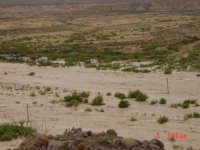
Terlingua Creek is roughly eighty miles long, smoothing out the wiggles of the channel. It's commonly dry--but after any sort of rainfall of an inch or two across the drainage, it'll run four to six feet deep at my crossing. I've seen it in flood at above ten feet and way over a quarter-mile wide.

The picture is of a record flood, Sept. 2004. Definitely navigable, if your brave pills have taken hold.

Art
 

Attachments

  • Picture 010.jpg
    Picture 010.jpg
    153.8 KB · Views: 37
As the others has said, it depends both on the the federal guide lines as well as state. Not sure if it is still like this, but years ago in MI you couldn't "own" water that was accessible through navigable waters. i.e. you could own a farm pond not fed by a stream, but not a pond that had a stream flowing to it. My friends and I use to "torment" an old farmer because we would put our jon boat in at the road, row up stream into "his" pond and fish. He called the sheriff repeatedly only to be told as long as we didn't tresspass to get there, there was nothing he could do. He presumed the creek was navigable since we were able to navigate up it to the pond. Fortunately for us the farmer wasn't inclined to start shooting at us and when he did try to damn up the creek, he was told he couldn't damn up a public waterway.
 
I got some first hand experience with this issue years ago on a canoe trip down the guadalupe. We beached our canoe along a nice little beech to rest up a bit and have some lunch in the shade of a bridge, some folks camped a little further up the beech(we didn't see them when we pulled in or we would went further and found another place for lunch) anyway, apparently they had bought the little 5 acre tract there along the river and a couple of guys come over and start threatening to call the law on us for tresspassing if we didn't leave immediately. Normally I'd have shrugged, and pointed the canoe downstream, however they kinda got under my skin and they also had a bit of an odd accent(could have been extras in the movie Fargo) so I told them go ahead and call the law. They did, sherriffs deputy shows up and informs them as long as we are below the high water line we aren't tresspassing. I offered the deputy a sandwich and a coke and he joined us for our lunch. So I think in Texas at least you can be fairly sure the local officers know the laws.
 
Yeah, as long as you're between the cutbanks, you're not trespassing.

If you can access a river--by climbing down the bank, e.g.--from a highway right-of-way at a bridge structure, you're not trespassing.

Again, Texas-specific.
 
Pretty sure its cool in New York as well. We ended up having to put up a warning sign on our creek due to the fact that the range we built is backed by the creek and we had a fly fisherman walk into the FOF during a firing break. Luckily we walked over the berm before firing again. We now do a berm walk at the beginning of shooting and after every break.
 
Art;
It has been some time since I read it, but I believe the definition of "navigatable stream" in Texas came from a 1939 TX SC ruling, may try to find it again, seem to remember it was 30' wide from permanent vegetation line and it had to flow into the Gulf, sooner or later.
A lot of ranchers try to block access, some get very violent and own the local laws, so it is a good idea to check out a specific steam, first.
Supposedly, there are some streams where the original Spanish grants included the stream beds, have not seen a specific example, yet.
 
"Cutbank to cutbank", the vertical streambanks within which you have non-flood flows. I won't argue about the average width; it's been a few years. But 30' sounds more correct than 20', which I think I used earlier.

When Bob Armstrong was Land Commisioner, he canoed the Guadalupe as a big news deal, to make sure that ranchers owning land on both sides of a river got the message about free passage.

SFAIK, nothing from those old Spanish grants pertains to today's laws.

Art
 
A navigable waterway is defined as one which was used for commerce at the time of Statehood. In this case the adjacent landowners own to mean high water. On non-navigable waterways the adjacent land owners own to the center of channel, Various states have passed laws regarding access along the waterways for recreational purposes and this varies from state to state.
 
According to Federal law, a landowner cannot stop public use of the channel up to mean high water level of a navigable waterway. Not too sure what the definition of "navigable" is, though. But I have seen some overgrown creeks that had pretty steady traffic on them.
That is the key official navigable designation and state laws on the subj.
 
Back
Top